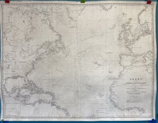
Chart of the North Atlantic Ocean from the Equator to 65 North Latitude According to the Latest Surveys and Observations
New York: E. & G. Blunt, 179 Water Street, SE Corner Burling Slip, 1832/Additions to 1857. W. Hooker, engraver; D.R. Harrison, lettering. Map no binding. Three hydrographic detail insets: The Virgin Rocks and the Surrounding Bank from Recent Surveys; Georges Shoals; and Nantucket Shoals from the U.S. Coast Survey, 1846..... More