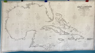
Chart of the Gulf of Mexico and Windward Passages including the Islands of Cuba, Haiti, Jamaica, Porto Rico, and the Bahamas. Compiled principally from the surveys made by the order of the British, Spanish, and United States Governments
London: James Imray & Son, 89 & 102 Minories, 1858. Map no binding. 40” X 74” within the neat line; three sheet blue-back chart; lighthouses indicated with red and yellow hand-coloring; light damp staining to the edge and a few scattered light stains; cleaned, conserved, and infill to areas of..... More