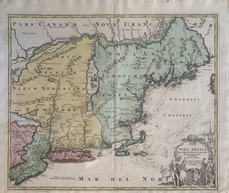
Nova Anglia, Septentrionali Americae implantata Anglorumique coloniis florentissima Geographice exhibit
Norimberge (Nuremberg): No date [c. 1720]. Joh. Baptista HOMANN. Map no binding. English translation: New England. North American implanted English colonies bloom, Geographic exhibit.
21 ¼” x 25 ¼”, 19 1/8” x 22 ¾” within the neat line; plate line visible; narrow lower margin, not trimmed; hand-colored; horizontal fold as issued; large pictorial cartouche; light soiling to margins else fine. Near fine. Item #244
A beautiful and important Homann map of the colonies, some still labeled with their Dutch names. Shore line extending from what is now the northern part of the state of Maine to the southern tip of New Jersey, and inland including what are now the states of Maine, New Hampshire, Vermont, Massachusetts, Connecticut, Rhode Island, New York, Pennsylvania and New Jersey. Some lakes are shown in exaggerated size, Cape Cod is dissected by water at its “elbow” as is Long Island by a river and lake in the area of the Connetquot River. New Jersey, divided in to East and West is an interesting early notation on some maps. What is now Penobscot Bay in Maine is labeled Penebrock Bay at whose head lies an area labeled Norumbeag, also called Norumbega. Norumbega is a legendary settlement of great wealth found in some 16th century maps through colonization. Also labeled are Native America tribes, fishing banks and off-shore ledges. A large pictorial cartouche featuring a Native American trading a pelt to a European, firearms, beads hanging on a cask, and a deer figure in the scene, while a ships mast can be seen above the cartouche. An attractive and important early colonial map.
Price: $1,850.00